
Al-Jami'ah Sub-District topographic map
Interactive map
Click on the map to display elevation.
About this map
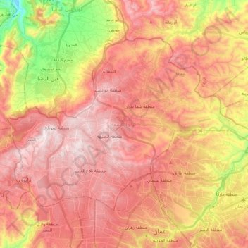
Name: Al-Jami'ah Sub-District topographic map, elevation, terrain.
Location: Al-Jami'ah Sub-District, Al-Jami'ah District, Amman, Jordan (31.96600 35.79664 32.08865 36.00423)
Average elevation: 2,799 ft
Minimum elevation: 1,486 ft
Maximum elevation: 3,606 ft
Other topographic maps
Click on a map to view its topography, its elevation and its terrain.
Ayn Hummar
Jordan > Amman > Al-Jami'ah Sub-District
Ayn Hummar, Sweileh, Al-Jami'ah Sub-District, Al-Jami'ah District, Amman, 11282, Jordan
Average elevation: 3,219 ft