Geolocate

Carthage topographic map

Click on the map to display elevation.

About this map

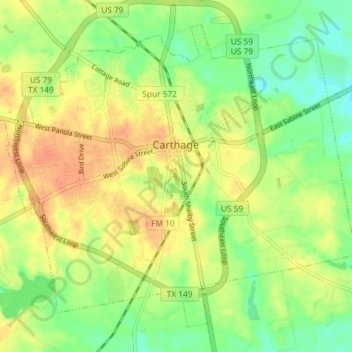
Name: Carthage topographic map, elevation, terrain.

Location: Carthage, Panola County, Texas, 75633, United States (32.12496 -94.37358 32.17811 -94.30062)

Average elevation: 289 ft

Minimum elevation: 220 ft

Maximum elevation: 351 ft

Panola County trails, hiking, mountain biking, running and outdoor activities

Other topographic maps

Click on a map to view its topography, its elevation and its terrain.

De Berry

United States > Texas > Panola County > De Berry

Average elevation: 335 ft

Gear up for your next adventure:

🔥Plasma Lighters - Windproof lighters that work in any weather condition
🌲Outdoor Survival Books - Best books on survival skills
🧦Hiking Socks - Comfortable socks to prevent blisters on long hikes
🦶Carbon Trekking Poles - Reduce knee impact on steep descents with ultra-light poles
🦶Hiking Gaiters - Keep debris and water out of your boots

As an Amazon Associate, this site earns from qualifying purchases at no extra cost to you.