
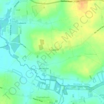
Blo' Norton topographic map
Interactive map
Click on the map to display elevation.
About this map
Name: Blo' Norton topographic map, elevation, terrain.
Average elevation: 112 ft
Minimum elevation: 69 ft
Maximum elevation: 177 ft
Other topographic maps
Click on a map to view its topography, its elevation and its terrain.
Bawdeswell Heath
United Kingdom > England > Norfolk > Breckland > Bawdeswell
Bawdeswell Heath, Bawdeswell, Breckland, Norfolk, East of England, England, NR20 4QY, United Kingdom
Average elevation: 138 ft
Little Cressingham
United Kingdom > England > Norfolk > Breckland > Little Cressingham
Little Cressingham, Breckland, Norfolk, East of England, England, United Kingdom
Average elevation: 141 ft
Cockley Cley
United Kingdom > England > Norfolk > Breckland > Cockley Cley
Cockley Cley, Breckland, Norfolk, East of England, England, United Kingdom
Average elevation: 125 ft
Little Ellingham
United Kingdom > England > Norfolk > Breckland > Little Ellingham
Little Ellingham, Breckland, Norfolk, East of England, England, United Kingdom
Average elevation: 177 ft