
Thank you for supporting this site ❤️
Make a donation
Make a donation
Gear up for your next adventure:
As an Amazon Associate, this site earns from qualifying purchases at no extra cost to you.
Ulutaş topographic map
Click on the map to display elevation.
Thank you for supporting this site ❤️
Make a donation
Make a donation
Gear up for your next adventure:
As an Amazon Associate, this site earns from qualifying purchases at no extra cost to you.
About this map
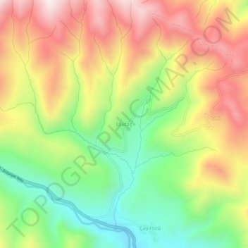
Name: Ulutaş topographic map, elevation, terrain.
Location: Ulutaş, İspir, Erzurum, Eastern Anatolia Region, Turkey (40.55764 40.88356 40.59764 40.92356)
Average elevation: 7,641 ft
Minimum elevation: 6,467 ft
Maximum elevation: 8,907 ft
Thank you for supporting this site ❤️
Make a donation
Make a donation
Gear up for your next adventure:
As an Amazon Associate, this site earns from qualifying purchases at no extra cost to you.