
Clemson Heights topographic map
Click on the map to display elevation.
About this map
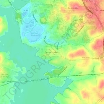
Name: Clemson Heights topographic map, elevation, terrain.
Average elevation: 712 ft
Minimum elevation: 614 ft
Maximum elevation: 860 ft
Pickens County trails, hiking, mountain biking, running and outdoor activities
Other topographic maps
Click on a map to view its topography, its elevation and its terrain.
Dawson Park
United States > South Carolina > Pickens County > Clemson > Briarwood
Average elevation: 764 ft