Geolocate

Grants Pass topographic map

Click on the map to display elevation.

About this map

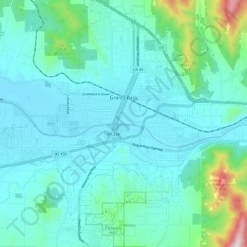
Name: Grants Pass topographic map, elevation, terrain.

Location: Grants Pass, Josephine County, Oregon, United States (42.38969 -123.39400 42.47168 -123.28756)

Average elevation: 1,227 ft

Minimum elevation: 879 ft

Maximum elevation: 3,127 ft

Josephine County trails, hiking, mountain biking, running and outdoor activities

Other topographic maps

Click on a map to view its topography, its elevation and its terrain.

O'Brien

United States > Oregon > Josephine County

Average elevation: 1,490 ft

Wilderville

United States > Oregon > Josephine County

Average elevation: 1,194 ft

Fruitdale

United States > Oregon > Josephine County > Grants Pass

Average elevation: 1,135 ft

Sunny Valley

United States > Oregon > Josephine County

Average elevation: 1,562 ft

Selma

United States > Oregon > Josephine County

Average elevation: 1,437 ft

Murphy

United States > Oregon > Josephine County

Average elevation: 1,289 ft

Gear up for your next adventure:

📚Navigation Handbooks - Master the art of reading topographic maps and using a compass
🚪Portable Camp Chair - Foldable chair for comfort at camp
🔭Stargazing Telescopes - Perfect for camping in low-light pollution areas shown on maps
🔭Telescopic Hiking Pole - Adjustable pole for hiking stability
GPS Sports Watch - GPS watch for running, hiking and training

As an Amazon Associate, this site earns from qualifying purchases at no extra cost to you.