
Tell City topographic map
Interactive map
Click on the map to display elevation.
About this map
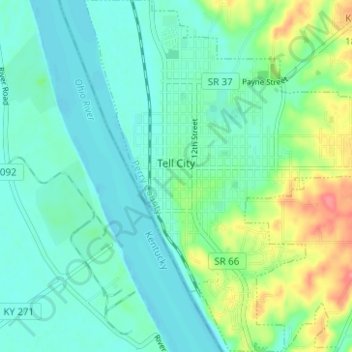
Name: Tell City topographic map, elevation, terrain.
Location: Tell City, Perry County, Indiana, United States (37.92502 -86.78401 37.97424 -86.72832)
Average elevation: 430 ft
Minimum elevation: 364 ft
Maximum elevation: 620 ft
Other topographic maps
Click on a map to view its topography, its elevation and its terrain.
Gerald
United States > Indiana > Perry County
Gerald, Perry County, Indiana, 47525, United States
Average elevation: 525 ft
Branchville
United States > Indiana > Perry County
Branchville, Perry County, Indiana, 47514, United States
Average elevation: 591 ft