
Lisvane topographic map
Interactive map
Click on the map to display elevation.
About this map
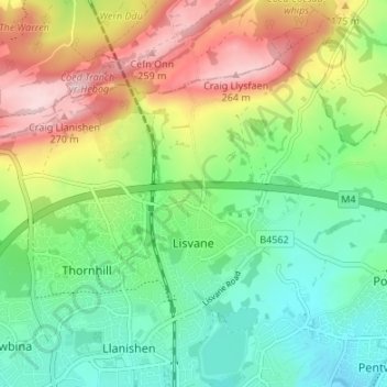
Name: Lisvane topographic map, elevation, terrain.
Location: Lisvane, Cardiff, Pays de Galles, CF, Royaume-Uni (51.53137 -3.21586 51.56050 -3.14868)
Average elevation: 374 ft
Minimum elevation: 66 ft
Maximum elevation: 886 ft
Other topographic maps
Click on a map to view its topography, its elevation and its terrain.
Gwaelod-y-garth
Royaume-Uni > Pays de Galles > Cardiff
Gwaelod-y-garth, Cardiff, Pays de Galles, CF15 9HG, Royaume-Uni
Average elevation: 407 ft
River Taff
Royaume-Uni > Pays de Galles > Cardiff > Cardiff
River Taff, Cardiff, Pays de Galles, CF, Royaume-Uni
Average elevation: 643 ft
Cardiff
Royaume-Uni > Pays de Galles > Cardiff
Cardiff, Pays de Galles, CF10 2AF, Royaume-Uni
Average elevation: 180 ft