
Itajubá topographic map
Interactive map
Click on the map to display elevation.
About this map
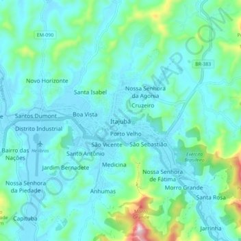
Name: Itajubá topographic map, elevation, terrain.
Average elevation: 3,028 ft
Minimum elevation: 2,746 ft
Maximum elevation: 4,521 ft
Gegründet wurde die Stadt 1819 von Padre Lourenço da Costa Moreira als Vila de Boa Vista. Noch heute ist ein Hotel nach den damals ansässigen Coroados-Indios benannt. Der Name Itajubá kommt allerdings aus der Sprache der Tupí, in der Originalform itaîuba, übersetzt von der Höhe hinabfallender Fluss der Steine (Wasserfall).