
Le Val du Puits topographic map
Interactive map
Click on the map to display elevation.
About this map
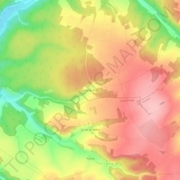
Name: Le Val du Puits topographic map, elevation, terrain.
Average elevation: 755 ft
Minimum elevation: 476 ft
Maximum elevation: 942 ft
Other topographic maps
Click on a map to view its topography, its elevation and its terrain.
Le Val du Puits
France > Bourgogne-Franche-Comté > Yonne > Vermenton
Le Val du Puits, Vermenton, Auxerre, Yonne, Bourgogne-Franche-Comté, France métropolitaine, 89270, France
Average elevation: 597 ft
Vermenton
France > Bourgogne-Franche-Comté > Yonne > Vermenton
Vermenton, Auxerre, Yonne, Bourgogne-Franche-Comté, France métropolitaine, 89270, France
Average elevation: 630 ft