
Sahraoui topographic map
Interactive map
Click on the map to display elevation.
About this map
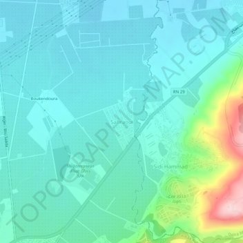
Name: Sahraoui topographic map, elevation, terrain.
Location: Sahraoui, Larbaa, Daïra Larbâa, Blida, 09300, Algérie (36.57458 3.15866 36.61458 3.19866)
Average elevation: 295 ft
Minimum elevation: 154 ft
Maximum elevation: 925 ft
Other topographic maps
Click on a map to view its topography, its elevation and its terrain.
Belaouadi
Algérie > Blida > Daïra Larbâa > Larbaa
Belaouadi, Larbaa, Daïra Larbâa, Blida, 16189, Algérie
Average elevation: 210 ft