Geolocate

Hadleigh topographic map

Click on the map to display elevation.

About this map

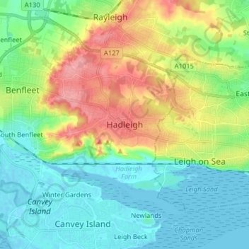
Name: Hadleigh topographic map, elevation, terrain.

Location: Hadleigh, Castle Point, Essex, England, SS7 2RD, United Kingdom (51.51392 0.56870 51.59392 0.64870)

Average elevation: 95 ft

Minimum elevation: -3 ft

Maximum elevation: 285 ft

Gear up for your next adventure:

☀️Outdoor Sunscreen - High protection sunscreen for outdoor activities
🪶Fire Starter Kit - Reliable fire starter for survival and camping
🦺Reflective Outdoor Gear - Safety gear for low‑light conditions
🧷Carabiner Set - Durable clips for gear attachment
🪶Camp Gear Gift Set - Perfect gift bundle for outdoor fans

As an Amazon Associate, this site earns from qualifying purchases at no extra cost to you.