
Make a donation
Gear up for your next adventure:
As an Amazon Associate, this site earns from qualifying purchases at no extra cost to you.
Linse topographic map
Click on the map to display elevation.
Make a donation
Gear up for your next adventure:
As an Amazon Associate, this site earns from qualifying purchases at no extra cost to you.
Linse
Das Dorf liegt auf der Nordseite des Höhenzuges Vogler. Der Spüligbach, ein Nebenfluss der Lenne, fließt mitten durch den Ort. Die Weser fließt 1,2 km entfernt westlich. Durch den nördlichen Bereich des Ortes verläuft die B 240.
Make a donation
Gear up for your next adventure:
As an Amazon Associate, this site earns from qualifying purchases at no extra cost to you.
About this map
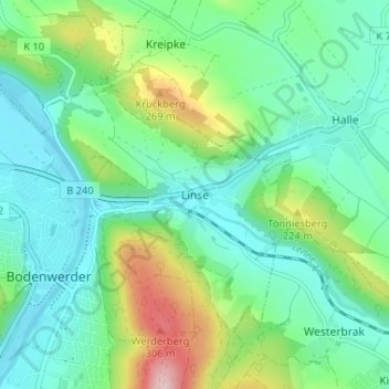
Name: Linse topographic map, elevation, terrain.
Average elevation: 479 ft
Minimum elevation: 223 ft
Maximum elevation: 1,191 ft
Make a donation
Gear up for your next adventure:
As an Amazon Associate, this site earns from qualifying purchases at no extra cost to you.
Other topographic maps
Click on a map to view its topography, its elevation and its terrain.