
Thank you for supporting this site ❤️
Make a donation
Make a donation
Gear up for your next adventure:
As an Amazon Associate, this site earns from qualifying purchases at no extra cost to you.
Großdubrau - Wulka Dubrawa topographic map
Click on the map to display elevation.
Thank you for supporting this site ❤️
Make a donation
Make a donation
Gear up for your next adventure:
As an Amazon Associate, this site earns from qualifying purchases at no extra cost to you.
About this map
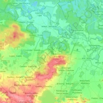
Name: Großdubrau - Wulka Dubrawa topographic map, elevation, terrain.
Location: Großdubrau - Wulka Dubrawa, Bautzen, Saxony, 02694, Germany (51.21473 14.40201 51.32749 14.56595)
Average elevation: 505 ft
Minimum elevation: 417 ft
Maximum elevation: 686 ft
Thank you for supporting this site ❤️
Make a donation
Make a donation
Gear up for your next adventure:
As an Amazon Associate, this site earns from qualifying purchases at no extra cost to you.
Other topographic maps
Click on a map to view its topography, its elevation and its terrain.
Koselbruch - Kózło
Germany > Saxony > Bautzen > Hoyerswerda - Wojerecy > Schwarzkollm - Čorny Chołmc
Average elevation: 436 ft