
Páka topographic map
Interactive map
Click on the map to display elevation.
About this map
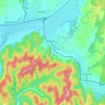
Name: Páka topographic map, elevation, terrain.
Average elevation: 669 ft
Minimum elevation: 515 ft
Maximum elevation: 1,027 ft
Other topographic maps
Click on a map to view its topography, its elevation and its terrain.
Lenti
Hongrie > Zala megye > Lenti > Lenti
Lenti, Lenti járás, Zala megye, Transdanubie occidentale, Transdanubie, 8960, Hongrie
Average elevation: 597 ft
Hosszúvölgy
Hosszúvölgy, Nagykanizsai járás, Zala megye, Transdanubie occidentale, Transdanubie, Hongrie
Average elevation: 617 ft