
Make a donation
Gear up for your next adventure:
As an Amazon Associate, this site earns from qualifying purchases at no extra cost to you.
Chernivtsi topographic map
Click on the map to display elevation.
Make a donation
Gear up for your next adventure:
As an Amazon Associate, this site earns from qualifying purchases at no extra cost to you.
Chernivtsi
The city is located in a temperate climate zone. The climate is continental with mild winters and warm summers. The average annual temperature is +8,6 °C (47 °F), the lowest in January (-2,9 °C; 27 °F), the highest – in July (+19,8 °C; 68 °F). Winter weather usually comes on 28 November and ends 9 March; summer weather begins on 20 May, and ends on 10 September. The average annual rainfall in Chernivtsi is 621 mm (24+1⁄2"), with the lowest – in October and January–February, the highest – in June–July. Sometimes there are heavy rains during the summer. Snow cover is formed each winter, but its altitude is insignificant. The average wind speed ranges from 3.3 m/s (7 mph) in July to 4.0 m/s (9 mph) in January. The average annual humidity is 77%.
Make a donation
Gear up for your next adventure:
As an Amazon Associate, this site earns from qualifying purchases at no extra cost to you.
About this map
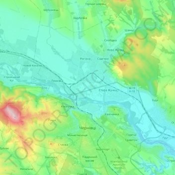
Name: Chernivtsi topographic map, elevation, terrain.
Average elevation: 741 ft
Minimum elevation: 463 ft
Maximum elevation: 1,729 ft
Make a donation
Gear up for your next adventure:
As an Amazon Associate, this site earns from qualifying purchases at no extra cost to you.
Other topographic maps
Click on a map to view its topography, its elevation and its terrain.
Make a donation
Gear up for your next adventure:
As an Amazon Associate, this site earns from qualifying purchases at no extra cost to you.