
Egem topographic map
Interactive map
Click on the map to display elevation.
About this map
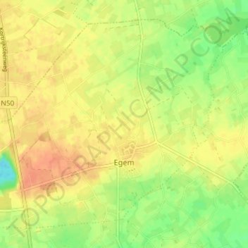
Name: Egem topographic map, elevation, terrain.
Location: Egem, Pittem, Tielt, Flandre-Occidentale, Belgique (51.00471 3.22275 51.03715 3.28367)
Average elevation: 112 ft
Minimum elevation: 36 ft
Maximum elevation: 164 ft
Other topographic maps
Click on a map to view its topography, its elevation and its terrain.
Wingene
Belgique > Flandre-Occidentale > Tielt > Wingene
Wingene, Tielt, Flandre-Occidentale, Flandre, 8750, Belgique
Average elevation: 75 ft
Dentergem
Belgique > Flandre-Occidentale > Tielt > Dentergem
Dentergem, Tielt, Flandre-Occidentale, Flandre, 8720, Belgique
Average elevation: 36 ft
Zwevezele
Belgique > Flandre-Occidentale > Tielt
Zwevezele, Wingene, Tielt, Flandre-Occidentale, Flandre, 8750, Belgique
Average elevation: 98 ft
Tielt
Belgique > Flandre-Occidentale > Tielt > Tielt
Tielt, Flandre-Occidentale, 8700, Belgique
Average elevation: 79 ft