
Village of Sands Point topographic map
Interactive map
Click on the map to display elevation.
About this map
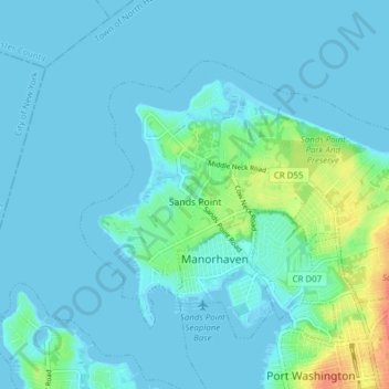
Name: Village of Sands Point topographic map, elevation, terrain.
Average elevation: 26 ft
Minimum elevation: -7 ft
Maximum elevation: 184 ft
Other topographic maps
Click on a map to view its topography, its elevation and its terrain.
East Massapequa
United States > New York > Nassau County
East Massapequa, Town of Oyster Bay, Nassau County, New York, United States
Average elevation: 26 ft
Port Washington
United States > New York > Nassau County
Port Washington, Town of North Hempstead, Nassau County, New York, United States
Average elevation: 69 ft
North New Hyde Park
United States > New York > Nassau County
North New Hyde Park, Town of North Hempstead, Nassau County, New York, 11040, United States
Average elevation: 118 ft
Village of East Hills
United States > New York > Nassau County
Village of East Hills, Town of North Hempstead, Nassau County, New York, United States
Average elevation: 187 ft
University Gardens
United States > New York > Nassau County
University Gardens, Town of North Hempstead, Nassau County, New York, United States
Average elevation: 151 ft
Merrick
United States > New York > Nassau County
Merrick, Town of Hempstead, Nassau County, New York, 11566, United States
Average elevation: 16 ft
New Cassel
United States > New York > Nassau County
New Cassel, Town of North Hempstead, Nassau County, New York, 11590, United States
Average elevation: 135 ft
Village of Hempstead
United States > New York > Nassau County
Village of Hempstead, Town of Hempstead, Nassau County, New York, 11550, United States
Average elevation: 66 ft
Baldwin
United States > New York > Nassau County
Baldwin, Town of Hempstead, Nassau County, New York, 11510, United States
Average elevation: 26 ft
Village of Great Neck
United States > New York > Nassau County
Village of Great Neck, Town of North Hempstead, Nassau County, New York, 11023, United States
Average elevation: 62 ft
Village of Roslyn Harbor
United States > New York > Nassau County
Village of Roslyn Harbor, Town of North Hempstead, Nassau County, New York, United States
Average elevation: 112 ft
North Wantagh
United States > New York > Nassau County
North Wantagh, Town of Hempstead, Nassau County, New York, United States
Average elevation: 56 ft
Lakeview
United States > New York > Nassau County
Lakeview, Town of Hempstead, Nassau County, New York, United States
Average elevation: 39 ft
Village of Flower Hill
United States > New York > Nassau County
Village of Flower Hill, Town of North Hempstead, Nassau County, New York, United States
Average elevation: 138 ft
Salisbury
United States > New York > Nassau County
Salisbury, Town of Hempstead, Nassau County, New York, United States
Average elevation: 112 ft
Village of Saddle Rock
United States > New York > Nassau County
Village of Saddle Rock, Town of North Hempstead, Nassau County, New York, United States
Average elevation: 36 ft
City of Glen Cove
United States > New York > Nassau County
City of Glen Cove, Nassau County, New York, United States
Average elevation: 39 ft
South Farmingdale
United States > New York > Nassau County
South Farmingdale, Town of Oyster Bay, Nassau County, New York, 11735, United States
Average elevation: 62 ft
Village of Kensington
United States > New York > Nassau County
Village of Kensington, Town of North Hempstead, Nassau County, New York, United States
Average elevation: 98 ft
North Massapequa
United States > New York > Nassau County
North Massapequa, Town of Oyster Bay, Nassau County, New York, 11758, United States
Average elevation: 49 ft
Village of Hewlett Bay Park
United States > New York > Nassau County
Village of Hewlett Bay Park, Town of Hempstead, Nassau County, New York, 11557, United States
Average elevation: 16 ft
North Valley Stream
United States > New York > Nassau County
North Valley Stream, Town of Hempstead, Nassau County, New York, United States
Average elevation: 46 ft
Wantagh
United States > New York > Nassau County
Wantagh, Town of Hempstead, Nassau County, New York, 11793, United States
Average elevation: 20 ft
Old Bethpage
United States > New York > Nassau County
Old Bethpage, Town of Oyster Bay, Nassau County, New York, 11804, United States
Average elevation: 135 ft
Franklin Square
United States > New York > Nassau County
Franklin Square, Town of Hempstead, Nassau County, New York, 11010, United States
Average elevation: 62 ft
Oyster Bay
United States > New York > Nassau County
Oyster Bay, Town of Oyster Bay, Nassau County, New York, 11771, United States
Average elevation: 115 ft
Village of Lawrence
United States > New York > Nassau County
Village of Lawrence, Town of Hempstead, Nassau County, New York, 11559, United States
Average elevation: 13 ft
Village of Great Neck Plaza
United States > New York > Nassau County
Village of Great Neck Plaza, Town of North Hempstead, Nassau County, New York, 11021, United States
Average elevation: 105 ft
Village of Valley Stream
United States > New York > Nassau County
Village of Valley Stream, Town of Hempstead, Nassau County, New York, 11580, United States
Average elevation: 23 ft
Village of Roslyn Estates
United States > New York > Nassau County
Village of Roslyn Estates, Town of North Hempstead, Nassau County, New York, United States
Average elevation: 180 ft
Village of Bayville
United States > New York > Nassau County
Village of Bayville, Town of Oyster Bay, Nassau County, New York, 11709, United States
Average elevation: 23 ft
Plainview
United States > New York > Nassau County
Plainview, Town of Oyster Bay, Nassau County, New York, 11803, United States
Average elevation: 194 ft
Roslyn Heights
United States > New York > Nassau County
Roslyn Heights, Town of North Hempstead, Nassau County, New York, United States
Average elevation: 157 ft
Bethpage
United States > New York > Nassau County
Bethpage, Town of Oyster Bay, Nassau County, New York, 11714, United States
Average elevation: 125 ft
Village of Island Park
United States > New York > Nassau County
Village of Island Park, Town of Hempstead, Nassau County, New York, 11558, United States
Average elevation: 3 ft
Tackapausha Pond
United States > New York > Nassau County > Seaford
Tackapausha Pond, Seaford, Town of Hempstead, Nassau County, New York, United States
Average elevation: 16 ft
Eisenhower Park
United States > New York > Nassau County > East Meadow
Eisenhower Park, East Meadow, Town of Hempstead, Nassau County, New York, United States
Average elevation: 98 ft
Massapequa Park
United States > New York > Nassau County > Massapequa Park
Massapequa Park, Town of Oyster Bay, Nassau County, New York, 11758, United States
Average elevation: 30 ft
Oceanside
United States > New York > Nassau County
Oceanside, Town of Hempstead, Nassau County, New York, 11572, United States
Average elevation: 13 ft
Village of New Hyde Park
United States > New York > Nassau County
Village of New Hyde Park, Town of North Hempstead, Nassau County, New York, United States
Average elevation: 105 ft
Village of Rockville Centre
United States > New York > Nassau County
Village of Rockville Centre, Town of Hempstead, Nassau County, New York, 11570, United States
Average elevation: 36 ft
Village of Kings Point
United States > New York > Nassau County
Village of Kings Point, Town of North Hempstead, Nassau County, New York, 11024, United States
Average elevation: 30 ft
Village of Bellerose
United States > New York > Nassau County
Village of Bellerose, Town of Hempstead, Nassau County, New York, United States
Average elevation: 92 ft
Town of Oyster Bay
United States > New York > Nassau County
Town of Oyster Bay, Nassau County, New York, United States
Average elevation: 59 ft
Village of Port Washington North
United States > New York > Nassau County
Village of Port Washington North, Town of North Hempstead, Nassau County, New York, United States
Average elevation: 56 ft
Town of Hempstead
United States > New York > Nassau County
Town of Hempstead, Nassau County, New York, United States
Average elevation: 33 ft
Elmont
United States > New York > Nassau County
Elmont, Town of Hempstead, Nassau County, New York, 11003, United States
Average elevation: 69 ft
Glen Head
United States > New York > Nassau County
Glen Head, Town of Oyster Bay, Nassau County, New York, United States
Average elevation: 131 ft
Village of Stewart Manor
United States > New York > Nassau County > Village of Stewart Manor
Village of Stewart Manor, Town of Hempstead, Nassau County, New York, United States
Average elevation: 89 ft
Village of Farmingdale
United States > New York > Nassau County
Village of Farmingdale, Town of Oyster Bay, Nassau County, New York, United States
Average elevation: 82 ft