
Thank you for supporting this site ❤️
Make a donation
Make a donation
Gear up for your next adventure:
As an Amazon Associate, this site earns from qualifying purchases at no extra cost to you.
Arauco topographic map
Click on the map to display elevation.
Thank you for supporting this site ❤️
Make a donation
Make a donation
Gear up for your next adventure:
As an Amazon Associate, this site earns from qualifying purchases at no extra cost to you.
About this map
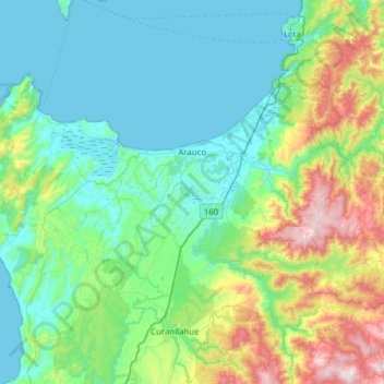
Name: Arauco topographic map, elevation, terrain.
Location: Arauco, Provincia de Arauco, Biobío Region, 0000045, Chile (-37.45059 -73.68503 -37.14494 -73.06569)
Average elevation: 643 ft
Minimum elevation: -3 ft
Maximum elevation: 3,123 ft
Thank you for supporting this site ❤️
Make a donation
Make a donation
Gear up for your next adventure:
As an Amazon Associate, this site earns from qualifying purchases at no extra cost to you.