Orléans topographic map
Click on the map to display elevation.
Orléans
At the end of the 1960s, the Orléans-la-Source [fr] neighbourhood was created, 12 kilometres (7 mi)to the south of the original commune and separated from it by the Val d'Orléans and the river Loiret (whose source is in the Parc Floral de la Source). This quarter's altitude varies from about 100 to 110 m (330 to 360 ft).
About this map
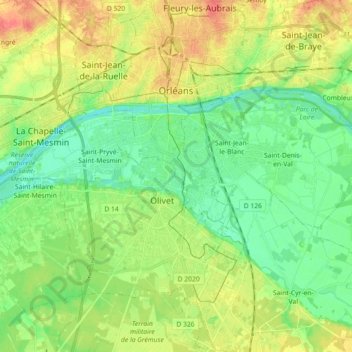
Name: Orléans topographic map, elevation, terrain.
Average elevation: 341 ft
Minimum elevation: 279 ft
Maximum elevation: 436 ft
Other topographic maps
Click on a map to view its topography, its elevation and its terrain.

Maison Forestière des Cordelières
France > Centre-Val de Loire > Loiret > Vitry-aux-Loges
Average elevation: 407 ft

Terres du Gd Sous Les Vign
France > Centre-Val de Loire > Loiret > Dordives > Le Grand-sous-les-Vignes
Average elevation: 305 ft


La Porte, Château
France > Centre-Val de Loire > Loiret > Autruy-sur-Juine > La Porte
Average elevation: 397 ft