Geolocate

Tuttle topographic map

Click on the map to display elevation.

About this map

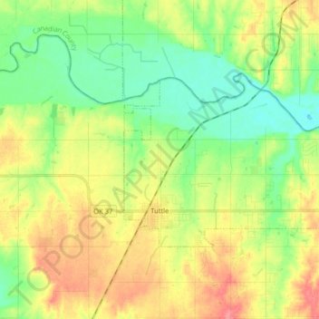
Name: Tuttle topographic map, elevation, terrain.

Location: Tuttle, Grady County, Oklahoma, 73089, United States (35.27619 -97.83014 35.34691 -97.67086)

Average elevation: 1,283 ft

Minimum elevation: 1,188 ft

Maximum elevation: 1,414 ft

Grady County trails, hiking, mountain biking, running and outdoor activities

Other topographic maps

Click on a map to view its topography, its elevation and its terrain.

Middleberg

United States > Oklahoma > Grady County

Average elevation: 1,286 ft

Gear up for your next adventure:

📶Satellite Messenger - Communication device off‑grid
📡GPS Antenna Upgrade - Enhance GPS reception in remote terrain
🚁Photography Drones - Capture stunning aerial views of landforms and topography
🔦Powerful Headlamps - Ultra-bright hands-free lighting for night navigation
🧼Biodegradable Camping Soap - Eco‑friendly soap for outdoor hygiene

As an Amazon Associate, this site earns from qualifying purchases at no extra cost to you.