
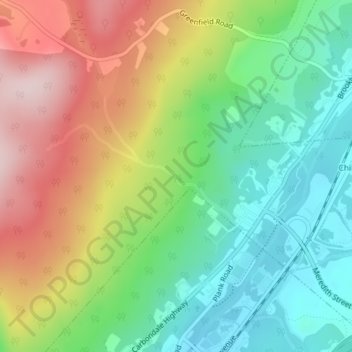
Lees Creek topographic map
Interactive map
Click on the map to display elevation.
About this map
Name: Lees Creek topographic map, elevation, terrain.
Average elevation: 1,368 ft
Minimum elevation: 951 ft
Maximum elevation: 1,972 ft
Other topographic maps
Click on a map to view its topography, its elevation and its terrain.
Windfall
États-Unis > Pennsylvanie > Windfall
Windfall, Bradford County, Pennsylvanie, États-Unis
Average elevation: 1,486 ft
Cumberland
Cumberland, Pennsylvanie, 17081, États-Unis
Average elevation: 827 ft
Franklin County
Franklin County, Pennsylvanie, États-Unis
Average elevation: 997 ft
Clinton County
Clinton County, Pennsylvanie, États-Unis
Average elevation: 1,526 ft
Northumberland County
Northumberland County, Pennsylvanie, États-Unis
Average elevation: 820 ft
Morewood
États-Unis > Pennsylvanie > East Huntingdon Township > Morewood
Morewood, East Huntingdon Township, Westmoreland County, Pennsylvanie, 15666, États-Unis
Average elevation: 1,171 ft