
Clyde topographic map
Interactive map
Click on the map to display elevation.
About this map
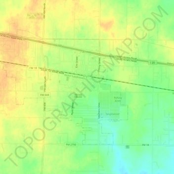
Name: Clyde topographic map, elevation, terrain.
Location: Clyde, Callahan County, Texas, United States (32.38689 -99.53748 32.41886 -99.48035)
Average elevation: 2,001 ft
Minimum elevation: 1,936 ft
Maximum elevation: 2,047 ft
Other topographic maps
Click on a map to view its topography, its elevation and its terrain.
Oplin
United States > Texas > Callahan County
Oplin, Callahan County, Texas, United States
Average elevation: 1,995 ft
Rowden
United States > Texas > Callahan County
Rowden, Callahan County, Texas, United States
Average elevation: 1,880 ft
Dudley
United States > Texas > Callahan County
Dudley, Callahan County, Texas, United States
Average elevation: 2,051 ft
Cross Plains
United States > Texas > Callahan County
Cross Plains, Callahan County, Texas, 76443, United States
Average elevation: 1,736 ft
Baird
United States > Texas > Callahan County
Baird, Callahan County, Texas, 79504, United States
Average elevation: 1,762 ft
Clyde
United States > Texas > Callahan County > Clyde
Clyde, Callahan County, Texas, United States
Average elevation: 2,005 ft