Geolocate

Clyde topographic map

Click on the map to display elevation.

About this map

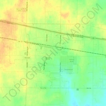
Name: Clyde topographic map, elevation, terrain.

Location: Clyde, Callahan County, Texas, United States (32.38689 -99.53748 32.41886 -99.48035)

Average elevation: 2,001 ft

Minimum elevation: 1,936 ft

Maximum elevation: 2,047 ft

Callahan County trails, hiking, mountain biking, running and outdoor activities

Other topographic maps

Click on a map to view its topography, its elevation and its terrain.

Cross Plains

United States > Texas > Callahan County

Average elevation: 1,736 ft

Dudley

United States > Texas > Callahan County

Average elevation: 2,051 ft

Oplin

United States > Texas > Callahan County

Average elevation: 1,995 ft

Rowden

United States > Texas > Callahan County

Average elevation: 1,880 ft

Baird

United States > Texas > Callahan County

Average elevation: 1,762 ft

Gear up for your next adventure:

🧭Map Reading Tools - Tools and kits for map navigation
🚑Emergency Bivvies - Heat-reflective sleeping bags for survival situations
Backpacking Tent - Lightweight and durable tent for multi‑day hikes
🧤Hiking Gloves - Protective gloves for rugged trails
🚪Portable Camp Chair - Foldable chair for comfort at camp

As an Amazon Associate, this site earns from qualifying purchases at no extra cost to you.