
Ameixial topographic map
Interactive map
Click on the map to display elevation.
About this map
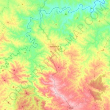
Name: Ameixial topographic map, elevation, terrain.
Location: Ameixial, Loulé, Faro, Algarve, Portugal (37.28790 -8.04397 37.41826 -7.87828)
Average elevation: 1,230 ft
Minimum elevation: 676 ft
Maximum elevation: 1,923 ft
Other topographic maps
Click on a map to view its topography, its elevation and its terrain.
Moita Longa
Moita Longa, Ameixial, Loulé, Faro, Algarve, Portugal
Average elevation: 1,352 ft