
Madrona topographic map
Interactive map
Click on the map to display elevation.
About this map
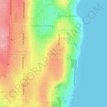
Name: Madrona topographic map, elevation, terrain.
Average elevation: 190 ft
Minimum elevation: 3 ft
Maximum elevation: 453 ft
Other topographic maps
Click on a map to view its topography, its elevation and its terrain.
Rainier Vista
United States of America > Washington > Seattle > Rainier Vista
Rainier Vista, King County, Washington, 98108, United States of America
Average elevation: 151 ft
Tamill
United States of America > Washington > Seattle > Tamill
Tamill, Seattle, King County, Washington, 98178, United States of America
Average elevation: 138 ft