
Make a donation
Gear up for your next adventure:
As an Amazon Associate, this site earns from qualifying purchases at no extra cost to you.
Tualatin topographic map
Click on the map to display elevation.
Make a donation
Gear up for your next adventure:
As an Amazon Associate, this site earns from qualifying purchases at no extra cost to you.
About this map
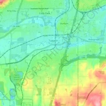
Name: Tualatin topographic map, elevation, terrain.
Location: Tualatin, Washington County, Oregon, 97062, United States (45.34703 -122.81784 45.40262 -122.72191)
Average elevation: 230 ft
Minimum elevation: 75 ft
Maximum elevation: 594 ft
Washington County trails, hiking, mountain biking, running and outdoor activities
Make a donation
Gear up for your next adventure:
As an Amazon Associate, this site earns from qualifying purchases at no extra cost to you.
Other topographic maps
Click on a map to view its topography, its elevation and its terrain.
Make a donation
Gear up for your next adventure:
As an Amazon Associate, this site earns from qualifying purchases at no extra cost to you.
Vern Galaway Memorial Park
United States > Oregon > Washington County > North Plains
Average elevation: 184 ft