
Make a donation
Gear up for your next adventure:
As an Amazon Associate, this site earns from qualifying purchases at no extra cost to you.
Trevélez topographic map
Click on the map to display elevation.
Make a donation
Gear up for your next adventure:
As an Amazon Associate, this site earns from qualifying purchases at no extra cost to you.
Trevélez
Located at a height of 1486 metres, Trevélez is not the highest recognised municipality in Spain. That honour goes to Valdelinares located in the Sierra de Gúdar range of the Sistema Ibérico, in the province of Teruel, Aragon, Spain. It lies at the confluence of the Río Trevélez with a smaller stream, to the southwest of Mulhacén, the highest peak of the Sierra Nevada and of the Iberian peninsula. The village lies to the west of the Río Trevélez. It is divided into three parts, the Barrios Bajo, Medio and Alto (lower, mid and upper quarters), with 200 metres of altitude difference between the highest and lowest points. The only bridge over the river is in the Barrio Bajo. The Barrio Bajo is a significant tourist centre, while the Barrios Medio and Alto are more typically Alpujarran in style, though tourism is important to the economy of the entire village. To the west, the nearest village is Busquístar; the road through the Bajo Barrio continues to the east and south to Juviles and Torvizcón. There is a regular bus service along this road, linking the village to the regional centres of Lanjarón and Órgiva as well as the provincial capital, Granada.
Make a donation
Gear up for your next adventure:
As an Amazon Associate, this site earns from qualifying purchases at no extra cost to you.
About this map
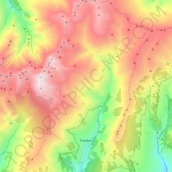
Name: Trevélez topographic map, elevation, terrain.
Average elevation: 7,713 ft
Minimum elevation: 3,957 ft
Maximum elevation: 11,394 ft
Make a donation
Gear up for your next adventure:
As an Amazon Associate, this site earns from qualifying purchases at no extra cost to you.
Other topographic maps
Click on a map to view its topography, its elevation and its terrain.
Cortijo ruinas
Spain > Andalusia > Comarca de la Alpujarra Granadina > Capileira
Average elevation: 7,369 ft
El Encinarillo
Spain > Andalusia > Comarca de la Alpujarra Granadina > Válor
Average elevation: 5,633 ft
Sierra Nevada
Spain > Andalusia > Comarca de la Alpujarra Granadina > Lanjarón
Average elevation: 7,293 ft
Make a donation
Gear up for your next adventure:
As an Amazon Associate, this site earns from qualifying purchases at no extra cost to you.
Pico de Mulhacén
Spain > Andalusia > Comarca de la Alpujarra Granadina > Trevélez
Mulhacén ([mulaˈθen]), with an elevation of 3,482 metres (11,424 ft), is the highest mountain in peninsular Spain and in all of the Iberian Peninsula. It is part of the Sierra Nevada range in the Penibaetic System. It is named after Abu'l-Hasan Ali, known as Muley Hacén in Spanish, the penultimate Muslim…
Average elevation: 10,072 ft
Pico del Veleta
Spain > Andalusia > Comarca de la Alpujarra Granadina > Capileira
The IRAM 30m telescope is located on the slopes of Pico Veleta, at an elevation of 2920 m.
Average elevation: 9,836 ft