Geolocate

岔科镇 topographic map

Interactive map

Click on the map to display elevation.

About this map

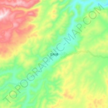
Name: 岔科镇 topographic map, elevation, terrain.

Location: 岔科镇, 建水县, 红河哈尼族彝族自治州, 云南省, 中国 (23.83036 103.00250 23.91036 103.08250)

Average elevation: 5,095 ft

Minimum elevation: 4,144 ft

Maximum elevation: 6,526 ft

Other topographic maps

Click on a map to view its topography, its elevation and its terrain.

普雄乡

中国 > 云南省 > 建水县

普雄乡, 建水县, 红河哈尼族彝族自治州, 云南省, 中国

Average elevation: 6,608 ft

右所

中国 > 云南省 > 建水县

右所, 建水县, 红河哈尼族彝族自治州, 云南省, 中国

Average elevation: 4,301 ft

李浩寨乡

中国 > 云南省 > 建水县

李浩寨乡, 建水县, 红河哈尼族彝族自治州, 云南省, 中国

Average elevation: 5,751 ft

建水县

中国 > 云南省 > 建水县

建水县, 红河哈尼族彝族自治州, 云南省, 中国

Average elevation: 5,154 ft

临安镇

中国 > 云南省 > 建水县

临安镇, 建水县, 红河哈尼族彝族自治州, 云南省, 中国

Average elevation: 4,406 ft

盘江乡

中国 > 云南省 > 建水县

盘江乡, 建水县, 红河哈尼族彝族自治州, 云南省, 中国

Average elevation: 4,560 ft