
Δημοτική Ενότητα Θήρας topographic map
Interactive map
Click on the map to display elevation.
About this map
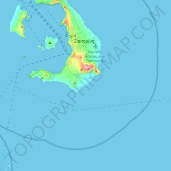
Name: Δημοτική Ενότητα Θήρας topographic map, elevation, terrain.
Average elevation: 39 ft
Minimum elevation: -3 ft
Maximum elevation: 1,811 ft
Other topographic maps
Click on a map to view its topography, its elevation and its terrain.
Palea Kameni
Griechenland > Ägäis > Δημοτική Ενότητα Θήρας
Palea Kameni, Δημοτική Ενότητα Θήρας, Δήμος Θήρας, Regionalbezirk Thira, Region Südliche Ägäis, Ägäis, Griechenland
Average elevation: 33 ft