
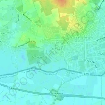
Kasteel Huis Bergh topographic map
Interactive map
Click on the map to display elevation.
About this map
Name: Kasteel Huis Bergh topographic map, elevation, terrain.
Average elevation: 69 ft
Minimum elevation: 36 ft
Maximum elevation: 154 ft
Other topographic maps
Click on a map to view its topography, its elevation and its terrain.
Kilder
Nederland > Gelderland > Montferland
Kilder, Montferland, Gelderland, Nederland
Average elevation: 89 ft
Hettenheuvel
Nederland > Gelderland > Montferland
Hettenheuvel, Montferland, Gelderland, Nederland, 7035DH, Nederland
Average elevation: 138 ft
Azewijn
Nederland > Gelderland > Montferland
Azewijn, Montferland, Gelderland, Nederland
Average elevation: 49 ft
Loerbeek
Nederland > Gelderland > Montferland
Loerbeek, Montferland, Gelderland, Nederland
Average elevation: 82 ft
Hulzenberg
Nederland > Gelderland > Montferland
Hulzenberg, Montferland, Gelderland, Nederland, 7039CV, Nederland
Average elevation: 112 ft