
Thank you for supporting this site ❤️
Make a donation
Make a donation
Gear up for your next adventure:
As an Amazon Associate, this site earns from qualifying purchases at no extra cost to you.
Böblingen topographic map
Click on the map to display elevation.
Thank you for supporting this site ❤️
Make a donation
Make a donation
Gear up for your next adventure:
As an Amazon Associate, this site earns from qualifying purchases at no extra cost to you.
About this map
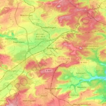
Name: Böblingen topographic map, elevation, terrain.
Location: Böblingen, Landkreis Böblingen, Baden-Württemberg, Germany (48.65502 8.93224 48.70376 9.11405)
Average elevation: 1,529 ft
Minimum elevation: 1,198 ft
Maximum elevation: 1,801 ft
Thank you for supporting this site ❤️
Make a donation
Make a donation
Gear up for your next adventure:
As an Amazon Associate, this site earns from qualifying purchases at no extra cost to you.
Other topographic maps
Click on a map to view its topography, its elevation and its terrain.
Merklingen
Germany > Baden-Württemberg > Landkreis Böblingen > Weil der Stadt
Average elevation: 1,430 ft