Geolocate

Douglas topographic map

Click on the map to display elevation.

About this map

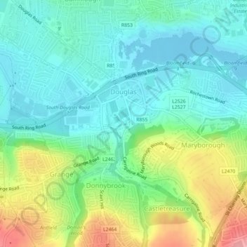
Name: Douglas topographic map, elevation, terrain.

Location: Douglas, Cork, County Cork, Munster, Ireland (51.86704 -8.44102 51.88109 -8.42171)

Average elevation: 112 ft

Minimum elevation: -13 ft

Maximum elevation: 367 ft

Other topographic maps

Click on a map to view its topography, its elevation and its terrain.

Lee Fields

Ireland > County Cork > Cork

Average elevation: 161 ft

Gear up for your next adventure:

🏫Relief Map Kits - Hands-on tools for teaching landforms and elevation
🧢Outdoor Hiking Hat - Sun protection hat for outdoor explorers
Solar GPS Watches - Advanced multisport watches with built-in topographic maps
🎒Outdoor Daypacks - Lightweight backpacks designed for carrying maps and essential gear
📌Outdoor GPS Map App - Apps and devices for digital topographic navigation

As an Amazon Associate, this site earns from qualifying purchases at no extra cost to you.