
Make a donation
Gear up for your next adventure:
As an Amazon Associate, this site earns from qualifying purchases at no extra cost to you.
Chaponost topographic map
Click on the map to display elevation.
Make a donation
Gear up for your next adventure:
As an Amazon Associate, this site earns from qualifying purchases at no extra cost to you.
About this map
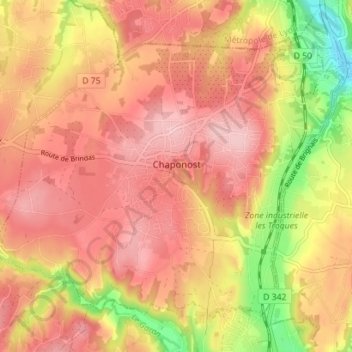
Name: Chaponost topographic map, elevation, terrain.
Average elevation: 915 ft
Minimum elevation: 584 ft
Maximum elevation: 1,096 ft
Make a donation
Gear up for your next adventure:
As an Amazon Associate, this site earns from qualifying purchases at no extra cost to you.
Other topographic maps
Click on a map to view its topography, its elevation and its terrain.
Flacelière
France > Auvergne-Rhône-Alpes > Rhône > Saint-Bonnet-des-Bruyères
Average elevation: 1,798 ft
Make a donation
Gear up for your next adventure:
As an Amazon Associate, this site earns from qualifying purchases at no extra cost to you.
Port de Beauregard
France > Auvergne-Rhône-Alpes > Rhône > Villefranche-sur-Saône > Port de Beauregard
Average elevation: 627 ft
Make a donation
Gear up for your next adventure:
As an Amazon Associate, this site earns from qualifying purchases at no extra cost to you.
Parc Popy
France > Auvergne-Rhône-Alpes > Rhône > Belleville-en-Beaujolais > Le Petit Quart
Average elevation: 587 ft