
Örebro topographic map
Interactive map
Click on the map to display elevation.
About this map
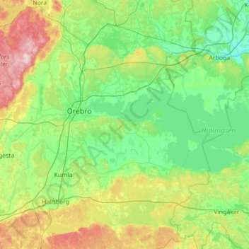
Name: Örebro topographic map, elevation, terrain.
Location: Örebro, Province Närke, Örebro County, Region Svealand, Sweden (58.93625 14.76059 59.51056 15.79853)
Average elevation: 240 ft
Minimum elevation: 13 ft
Maximum elevation: 955 ft
Other topographic maps
Click on a map to view its topography, its elevation and its terrain.
Hallsbergs kommun
Hallsbergs kommun, Örebro County, Region Svealand, Sweden
Average elevation: 289 ft
Ljusnaren
Ljusnaren, 63, Ljusnarsbergs kommun, Örebro County, Region Svealand, Sweden
Average elevation: 620 ft
Garphyttan
Sweden > Örebro County > Garphyttan
Garphyttan, Örebro, Örebro County, Region Svealand, 719 41, Sweden
Average elevation: 410 ft
Brevens bruk
Sweden > Örebro County > Brevens bruk
Brevens bruk, Örebro, Örebro County, Region Svealand, 715 96, Sweden
Average elevation: 305 ft
Tomtabacken
Sweden > Örebro County > Blåberga
Tomtabacken, Blåberga, Hallsberg, Province Närke, Örebro County, Region Svealand, 69491, Sweden
Average elevation: 236 ft