
Make a donation
Gear up for your next adventure:
As an Amazon Associate, this site earns from qualifying purchases at no extra cost to you.
Orreaga/Roncesvalles topographic map
Click on the map to display elevation.
Make a donation
Gear up for your next adventure:
As an Amazon Associate, this site earns from qualifying purchases at no extra cost to you.
Orreaga/Roncesvalles
Roncesvalles (/ˈrɒnsəvælz/ RON-sə-valz, Spanish: [ronθesˈβaʎes]; Basque: Orreaga [oreaɣa]; Aragonese: Ronzesbals [ɾonθezˈbals]; Occitan: Roncesvals; French: Roncevaux [ʁɔ̃s(ə)vo]) is a small village and municipality in Navarre, northern Spain. It is situated on the small river Urrobi at an altitude of some 900 metres (3,000 ft) in the Pyrenees, about 4 kilometres (2.5 mi) from the French border as the crow flies, or 21 kilometres (13 mi) by road.
Make a donation
Gear up for your next adventure:
As an Amazon Associate, this site earns from qualifying purchases at no extra cost to you.
About this map
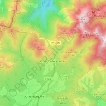
Name: Orreaga/Roncesvalles topographic map, elevation, terrain.
Average elevation: 3,363 ft
Minimum elevation: 1,913 ft
Maximum elevation: 5,016 ft
Make a donation
Gear up for your next adventure:
As an Amazon Associate, this site earns from qualifying purchases at no extra cost to you.
Other topographic maps
Click on a map to view its topography, its elevation and its terrain.