
Shamboyacu topographic map
Interactive map
Click on the map to display elevation.
About this map
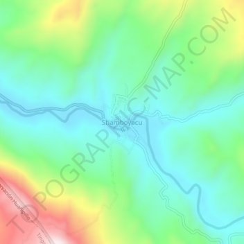
Name: Shamboyacu topographic map, elevation, terrain.
Location: Shamboyacu, Picota, San Martín, Perú (-7.04382 -76.15302 -7.00382 -76.11302)
Average elevation: 1,440 ft
Minimum elevation: 915 ft
Maximum elevation: 2,684 ft
Other topographic maps
Click on a map to view its topography, its elevation and its terrain.
Shamboyacu
Perú > San Martín > Shamboyacu
Shamboyacu, Provincia de Picota, San Martín, Perú
Average elevation: 2,251 ft