
Isla Mocha topographic map
Interactive map
Click on the map to display elevation.
About this map
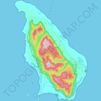
Name: Isla Mocha topographic map, elevation, terrain.
Average elevation: 131 ft
Minimum elevation: -3 ft
Maximum elevation: 1,240 ft
Other topographic maps
Click on a map to view its topography, its elevation and its terrain.
Yeneco
Chile > Región del Biobío > Provincia de Arauco > Lebu
Yeneco, Lebu, Provincia de Arauco, Región del Biobío, Chile
Average elevation: 541 ft
Lebu
Chile > Región del Biobío > Provincia de Arauco > Lebu
Lebu, Provincia de Arauco, Región del Biobío, 2, Chile
Average elevation: 486 ft
Pehuén
Chile > Región del Biobío > Provincia de Arauco > Lebu > Pehuén
Pehuén, Lebu, Provincia de Arauco, Región del Biobío, Chile
Average elevation: 581 ft