
Make a donation
Gear up for your next adventure:
As an Amazon Associate, this site earns from qualifying purchases at no extra cost to you.
Norwood topographic map
Click on the map to display elevation.
Make a donation
Gear up for your next adventure:
As an Amazon Associate, this site earns from qualifying purchases at no extra cost to you.
About this map
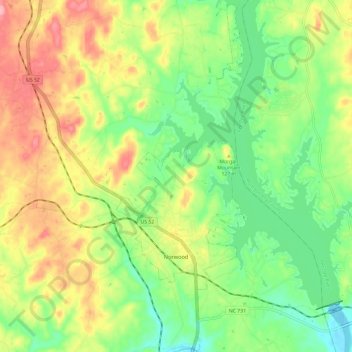
Name: Norwood topographic map, elevation, terrain.
Location: Norwood, Stanly County, North Carolina, United States (35.19335 -80.16435 35.29014 -80.09509)
Average elevation: 367 ft
Minimum elevation: 203 ft
Maximum elevation: 581 ft
Stanly County trails, hiking, mountain biking, running and outdoor activities
Make a donation
Gear up for your next adventure:
As an Amazon Associate, this site earns from qualifying purchases at no extra cost to you.
Other topographic maps
Click on a map to view its topography, its elevation and its terrain.
Forest Drive
United States > North Carolina > Stanly County > Albemarle > Forest Drive
Average elevation: 545 ft