
Thank you for supporting this site ❤️
Make a donation
Make a donation
Gear up for your next adventure:
As an Amazon Associate, this site earns from qualifying purchases at no extra cost to you.
Ferry topographic map
Click on the map to display elevation.
Thank you for supporting this site ❤️
Make a donation
Make a donation
Gear up for your next adventure:
As an Amazon Associate, this site earns from qualifying purchases at no extra cost to you.
About this map
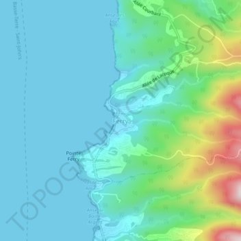
Name: Ferry topographic map, elevation, terrain.
Location: Ferry, Deshaies, Basse-Terre, Guadeloupe, 97126, France (16.25874 -61.82162 16.29874 -61.78162)
Average elevation: 289 ft
Minimum elevation: 0 ft
Maximum elevation: 1,496 ft
Thank you for supporting this site ❤️
Make a donation
Make a donation
Gear up for your next adventure:
As an Amazon Associate, this site earns from qualifying purchases at no extra cost to you.