
Janské Lázně topographic map
Interactive map
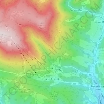
Click on the map to display elevation.
About this map
Name: Janské Lázně topographic map, elevation, terrain.
Average elevation: 2,694 ft
Minimum elevation: 1,657 ft
Maximum elevation: 4,275 ft
Janské Lázně is located about 11 km (7 mi) northwest of Trutnov and 46 km (29 mi) north of Hradec Králové. It lies in the Giant Mountains, and its northern part lies in the Krkonoše National Park. The highest point is the mountain Černá hora with an elevation of 1,299 m (4,262 ft). The Janský Creek springs here and flows through the municipality.