
San Augustin topographic map
Interactive map
Click on the map to display elevation.
About this map
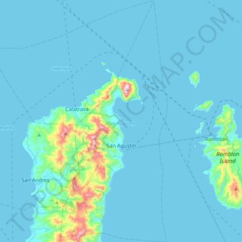
Name: San Augustin topographic map, elevation, terrain.
Location: San Augustin, Romblon, Mimaropa, 5501, Philippines (12.43363 122.04756 12.76982 122.20005)
Average elevation: 151 ft
Minimum elevation: 0 ft
Maximum elevation: 2,152 ft
Other topographic maps
Click on a map to view its topography, its elevation and its terrain.
Poblacion 1
Philippines > Romblon > Poblacion 1
Poblacion 1, Romblon, Mimaropa, Philippines
Average elevation: 269 ft