
Aragnouet topographic map
Interactive map
Click on the map to display elevation.
About this map
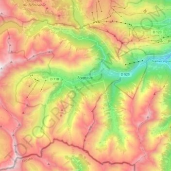
Name: Aragnouet topographic map, elevation, terrain.
Average elevation: 6,742 ft
Minimum elevation: 2,949 ft
Maximum elevation: 10,354 ft
Other topographic maps
Click on a map to view its topography, its elevation and its terrain.
Luquet
Francia > Occitania > Altos Pirineos > Luquet
Luquet, Tarbes, Altos Pirineos, Occitania, Francia metropolitana, 65320, Francia
Average elevation: 1,276 ft
Eget Village
Francia > Occitania > Altos Pirineos > Aragnouet > Eget Village
Eget Village, Aragnouet, Bagnères-de-Bigorre, Altos Pirineos, Occitania, Francia metropolitana, 65170, Francia
Average elevation: 5,118 ft