
Vadapalem topographic map
Interactive map
Click on the map to display elevation.
About this map
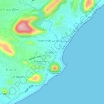
Name: Vadapalem topographic map, elevation, terrain.
Average elevation: 95 ft
Minimum elevation: 0 ft
Maximum elevation: 594 ft
Other topographic maps
Click on a map to view its topography, its elevation and its terrain.
Endada
India > Andhra Pradesh > Visakhapatnam (Rural)
Endada, Visakhapatnam (Rural), Visakhapatnam District, Andhra Pradesh, 530045, India
Average elevation: 161 ft
Pontinamallayyapalem
India > Andhra Pradesh > Visakhapatnam (Rural)
Pontinamallayyapalem, Visakhapatnam (Rural), Visakhapatnam, Andhra Pradesh, 530041, India
Average elevation: 230 ft