
Make a donation
Gear up for your next adventure:
As an Amazon Associate, this site earns from qualifying purchases at no extra cost to you.
Schwieberdingen topographic map
Click on the map to display elevation.
Make a donation
Gear up for your next adventure:
As an Amazon Associate, this site earns from qualifying purchases at no extra cost to you.
About this map
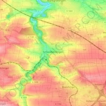
Name: Schwieberdingen topographic map, elevation, terrain.
Average elevation: 1,007 ft
Minimum elevation: 741 ft
Maximum elevation: 1,175 ft
Make a donation
Gear up for your next adventure:
As an Amazon Associate, this site earns from qualifying purchases at no extra cost to you.
Other topographic maps
Click on a map to view its topography, its elevation and its terrain.
Rielingshausen
Germany > Baden-Württemberg > Landkreis Ludwigsburg > Marbach am Neckar
Average elevation: 955 ft
Nussdorf
Germany > Baden-Württemberg > Landkreis Ludwigsburg
The municipality (Gemeinde) of Eberdingen is located at the western extremity of the district of Ludwigsburg, in the German state of Baden-Württemberg, along its border with the districts of Böblingen and the Enz. Eberdingen is physically located in the basin of [de] the Neckar. Elevation above sea level in…
Average elevation: 1,053 ft
Riet
Germany > Baden-Württemberg > Landkreis Ludwigsburg > Vaihingen an der Enz
Average elevation: 1,020 ft
Ground Zero
Germany > Baden-Württemberg > Landkreis Ludwigsburg > Ludwigsburg
Average elevation: 997 ft
Make a donation
Gear up for your next adventure:
As an Amazon Associate, this site earns from qualifying purchases at no extra cost to you.
Hohenhaslach
Germany > Baden-Württemberg > Landkreis Ludwigsburg > Sachsenheim
Average elevation: 922 ft