
Thank you for supporting this site ❤️
Make a donation
Make a donation
Gear up for your next adventure:
As an Amazon Associate, this site earns from qualifying purchases at no extra cost to you.
Kabwe topographic map
Click on the map to display elevation.
Thank you for supporting this site ❤️
Make a donation
Make a donation
Gear up for your next adventure:
As an Amazon Associate, this site earns from qualifying purchases at no extra cost to you.
About this map
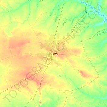
Name: Kabwe topographic map, elevation, terrain.
Location: Kabwe, Kabwe District, Central Province, Zambia (-14.60341 28.28652 -14.28341 28.60652)
Average elevation: 3,839 ft
Minimum elevation: 3,638 ft
Maximum elevation: 4,137 ft
Thank you for supporting this site ❤️
Make a donation
Make a donation
Gear up for your next adventure:
As an Amazon Associate, this site earns from qualifying purchases at no extra cost to you.