Geolocate

Talaga topographic map

Click on the map to display elevation.

About this map

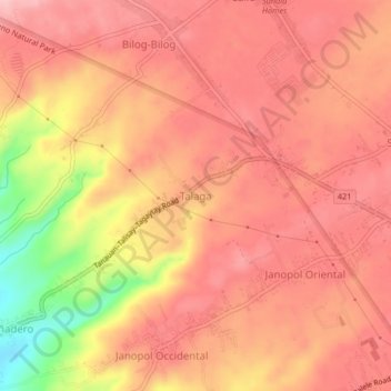
Name: Talaga topographic map, elevation, terrain.

Location: Talaga, Tanauan, Batangas, Calabarzon, 4232, Philippines (14.08094 121.07854 14.12094 121.11854)

Average elevation: 466 ft

Minimum elevation: 112 ft

Maximum elevation: 620 ft

Other topographic maps

Click on a map to view its topography, its elevation and its terrain.

Maria Paz

Philippines > Batangas > Tanauan

Average elevation: 210 ft

Barangay 3

Philippines > Batangas > Tanauan > Hidalgo

Average elevation: 518 ft

Barangay 5

Philippines > Batangas > Tanauan > Hidalgo

Average elevation: 505 ft

Suplang

Philippines > Batangas > Tanauan

Average elevation: 810 ft

Barangay 5

Philippines > Batangas > Tanauan > Hidalgo

Average elevation: 505 ft

Gear up for your next adventure:

🧥Waterproof Jacket for Hiking - Breathable and rugged rain jacket for outdoor excursions
💧Water Filtration Bottles - Safely drink from streams and lakes while exploring
📚USA Hiking Guide Books - Top trail guides and map books
🪶Fire Starter Kit - Reliable fire starter for survival and camping
🌲Outdoor Survival Books - Best books on survival skills

As an Amazon Associate, this site earns from qualifying purchases at no extra cost to you.