
Make a donation
Gear up for your next adventure:
As an Amazon Associate, this site earns from qualifying purchases at no extra cost to you.
Corinaldo topographic map
Click on the map to display elevation.
Make a donation
Gear up for your next adventure:
As an Amazon Associate, this site earns from qualifying purchases at no extra cost to you.
Corinaldo
At the end of the works, the new theater was very spacious and functional. According to Quagliani's design, an ingenious device was also prepared capable of making the stalls mobile, which was lowered on the occasion of theatrical performances and raised to create a single stage with the stage for dance parties and masked balls. After the 2006 restoration it definitively loses all its gadgets, from the elevation of the stalls to the stage machinery.
Make a donation
Gear up for your next adventure:
As an Amazon Associate, this site earns from qualifying purchases at no extra cost to you.
About this map
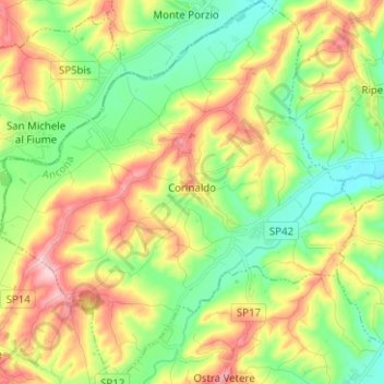
Name: Corinaldo topographic map, elevation, terrain.
Location: Corinaldo, Ancona, Marche, 60013, Italy (43.60236 12.98411 43.69304 13.10124)
Average elevation: 436 ft
Minimum elevation: 148 ft
Maximum elevation: 869 ft
Make a donation
Gear up for your next adventure:
As an Amazon Associate, this site earns from qualifying purchases at no extra cost to you.