Geolocate

Maracaibo topographic map

Click on the map to display elevation.

About this map

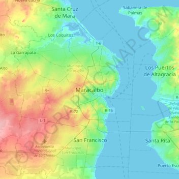
Name: Maracaibo topographic map, elevation, terrain.

Location: Maracaibo, Parroquia Cacique Mara, Municipio Maracaibo, Zulia State, 4012, Venezuela (10.48981 -71.80436 10.80981 -71.48436)

Average elevation: 92 ft

Minimum elevation: -13 ft

Maximum elevation: 331 ft

Other topographic maps

Click on a map to view its topography, its elevation and its terrain.

Gear up for your next adventure:

🛌Ultralight Sleeping Bags - Compact down bags for cold nights in the wilderness
Backpacking Tents - Weight-optimized shelters for multi-day topographic surveys
🧢Sun Protection Hats - Wide-brimmed and UPF-rated hats for high-altitude sun safety
🪶Thermal Camp Blanket - Extra warmth for cold nights
🔥Camping Stove - Portable stove for camping and backcountry cooking

As an Amazon Associate, this site earns from qualifying purchases at no extra cost to you.