
Askersunds kommun topographic map
Interactive map
Click on the map to display elevation.
About this map
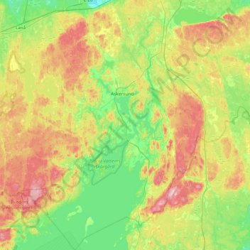
Name: Askersunds kommun topographic map, elevation, terrain.
Location: Askersunds kommun, Örebro County, Region Svealand, Sweden (58.64623 14.62491 59.02616 15.34759)
Average elevation: 433 ft
Minimum elevation: 213 ft
Maximum elevation: 827 ft
Other topographic maps
Click on a map to view its topography, its elevation and its terrain.
Sanna
Sweden > Örebro County > Örebro > Sanna
Sanna, Örebro, Örebro kommun, Örebro County, Region Svealand, 705 94, Sweden
Average elevation: 154 ft
Persberg
Sweden > Örebro County > Örebro
Persberg, Örebro, Örebro County, Region Svealand, 71594, Sweden
Average elevation: 262 ft
Kävesta
Sweden > Örebro County > Kävesta
Kävesta, Hallsberg, Örebro County, Region Svealand, 69774, Sweden
Average elevation: 148 ft
Lindesberg
Sweden > Örebro County > Lindesberg
Lindesberg, Lindesbergs kommun, Örebro County, Region Svealand, 711 30, Sweden
Average elevation: 279 ft
Tomtabacken
Sweden > Örebro County > Blåberga
Tomtabacken, Blåberga, Hallsberg, Province Närke, Örebro County, Region Svealand, 69491, Sweden
Average elevation: 236 ft
Vintrosa
Sweden > Örebro County > Vintrosa
Vintrosa, Örebro, Province Närke, Örebro County, Region Svealand, 71931, Sweden
Average elevation: 240 ft
Hällefors
Sweden > Örebro County > Hällefors
Hällefors, Örebro County, Region Svealand, 71234, Sweden
Average elevation: 673 ft